
BOSTON STREET MAP
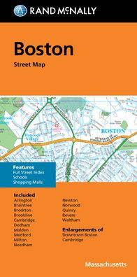
Rand McNally's folded map for Boston is a must-have for anyone traveling in and around this part of Massachusetts, offering unbeatable accuracy and reliability at a great price. Our trusted cartography shows all Interstate, U.S., state, and county highways, along with clearly indicated parks, points of interest, airports, county boundaries, and streets. The easy-to-use legend and detailed index make for quick and easy location of destinations. You'll see why Rand McNally folded maps have been the trusted standard for years. -Regularly updated. -Full-color maps. -Clearly labeled Interstate, U.S., state, and county highways. -Indications of parks, points of interest, airports, county boundaries, schools, shopping malls, downtown & vicinity maps. -Enlargements of downtown Boston and Cambridge. -Easy-to-use legend. -Detailed & full street index. -Convenient folded size. Coverage Area: Communities included, Arlington, Braintree, Brockton, Brookline, Cambridge, Dedham, Malden, Medford, Milton, Needham, Newton, Norwood, Quincy, Revere, Waltham. Product Details: Measures 9.5' x 4' and folds out to 40' x 28'.
1139993423
BOSTON STREET MAP
Rand McNally's folded map for Boston is a must-have for anyone traveling in and around this part of Massachusetts, offering unbeatable accuracy and reliability at a great price. Our trusted cartography shows all Interstate, U.S., state, and county highways, along with clearly indicated parks, points of interest, airports, county boundaries, and streets. The easy-to-use legend and detailed index make for quick and easy location of destinations. You'll see why Rand McNally folded maps have been the trusted standard for years. -Regularly updated. -Full-color maps. -Clearly labeled Interstate, U.S., state, and county highways. -Indications of parks, points of interest, airports, county boundaries, schools, shopping malls, downtown & vicinity maps. -Enlargements of downtown Boston and Cambridge. -Easy-to-use legend. -Detailed & full street index. -Convenient folded size. Coverage Area: Communities included, Arlington, Braintree, Brockton, Brookline, Cambridge, Dedham, Malden, Medford, Milton, Needham, Newton, Norwood, Quincy, Revere, Waltham. Product Details: Measures 9.5' x 4' and folds out to 40' x 28'.
8.99
In Stock
5
1


Product Details
| ISBN-13: | 9780528024511 |
|---|---|
| Publisher: | Rand McNally |
| Publication date: | 09/10/2021 |
| Pages: | 2 |
| Sales rank: | 464,980 |
| Product dimensions: | 4.25(w) x 9.00(h) x 0.25(d) |
From the B&N Reads Blog


